Forgive me, I'm going to get a bit pictorial on you.
Houston has two "reservoirs", both built in the 1930's out well beyond the limits of Houston at that time. I know the area where I live was farmland then; to the west of me (not far) are the grain silos and railroad tracks that took the produce from this land to market. The storage silos now stand as storage for boats and large vehicles; they are too massive to tear down. They are the last remnant of what was a thriving farm community (it was that community which built the church I came here to serve almost 20 years ago now, a church then 150 years old.). Still further west are the two reservoirs. As this article says, they were built to control flooding in Houston through Buffalo Bayou. The reservoirs were built to store water and then release it, in a controlled fashion, into Buffalo Bayou. I can only assume, at the time, that they released over farmland and prairie.
This is the area immediately around this reservoirs today:
That's the area being flooded by the "controlled release" from the reservoirs, a release that, if it isn't done, will see the dams overtopped and even more water flowing out, seeking the bayou and heading south of I-10 (one of the reservoirs is adjacent to the east-west interstate highway that bisects this city north and south).
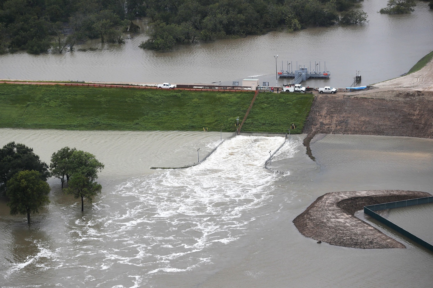
This is what the spillway looks like that is releasing that water:
Is covered in water, so that you can only identify the spillway by the turbulence in the water as it is released. Everything in the immediate vicinity of that spillway looks like the picture above. There are tall buildings there (office? Aparments?), parking lots, strip centers, gas stations, the usual accoutrement of suburban life along roadways. It is all under water. The outflow looks like this:
Behind the reservoir is underwater, too, because these reservoirs have a dam on only three sides, not four. Water is meant to stretch behind them, and behind both of them there are houses. Not immediately behind, but close enough they are flooded now. The buildings you see in the top picture are obviously flooded, but the water rushing out of the reservoirs and flooding that landscape is making its way to Buffalo Bayou, a watercourse that snakes its way through some of the most expensive residential real estate in the county; through neighborhoods where energy executives (read: oil) and wealthy doctors and lawyers and other professionals, live. All changed, changed utterly, for the ceremony of innocence through wealth is drowned; literally. From a helicopter you can barely identify the course of the bayou, because you can't distinguish it from the surrounding landscape: all is covered in water. The water is slowly making its way down the bayou to downtown Houston, which is flooded anyway, and now will be flooded again. Waters are receding in most of the areas of Houston drenched by Harvey; they are still rising in the areas downstream of these reservoirs.
As the article says, it may be a month before those waters are gone.
Harris County (the county that contains Houston, except for the parts that have spread into other counties) has an agency called Harris County Flood Control District. It's an obvious oxymoron at this point. HCFD doesn't control floods; it creates them. Nature did some of this to us; we did the rest ourselves.
I stumbled across this, looking for pictures of the current flooding. It's a list of the top 10 civil engineering achievements in Houston. These reservoirs are #1. Seriously:
Both the Addicks and Barker reservoirs help to prevent downstream flooding of the Buffalo Bayou which ultimately prevents flooding in the City of Houston. The Addicks reservoir is located in between Barker Cypress and the Sam Houston Tollway just north of Interstate 10, and covers approximately 26,000 acres. The Barker reservoir is located just to the south of Interstate 10 and west of Highway 6 and covers approx. 320 acres. Prior to the construction of these reservoirs in the late 1930’s, flooding was a serious problem within the City of Houston.These reservoirs may have contained the flooding, but neighborhoods that were dry before the release, are 4-6 feet deep in water now. The downstream flooding wasn't prevented, merely postponed; some will say, created.
The kind of thinking that praises the reservoirs as gifts of engineering, sadly, predominates in Houston. The Greeks called it hubris, and Aristotle said it was the main engine of tragedy. Whether we in Houston take responsibility for our actions, as a tragic hero does, or whether we shift the blame, as a coward does, remains to be seen.


This is just awful. I have been curious to see what Ron Paul has been gassing on about it but haven't had the heart to look it up. If it's not in a transcript, I don't want to know because I can't stand to hear that guy.
ReplyDeleteThis is as much the product of Classical Economics flowing from the University of Chicago as it is anyplace, and the same idea as legal theory flowing from so many other sources, not to mention the media. This is the product of PBS showing Milton Friedman in the late 1970s as it is anything else.
We've all got guilt, we've all got blood on our hands.